
New maps offer more detail to ocean planners about how animal concentrations change during the year
Ocean, Science Comments Off on New maps offer more detail to ocean planners about how animal concentrations change during the yearAn ongoing challenge for ocean regulators has been our relatively coarse understanding of where ocean animals are at any given time. For many species, we’ve been limited to relatively broad-brush data, such as regional population estimates or having a moderately clear idea about particular feeding or breedings areas, with limited knowledge of where these same animals go at other times of year. All this has made the crucial task of estimating the impacts of human activities (Naval sonar and explosives exercises, oil and gas seismic surveys, construction of new shipping ports) somewhere between difficult and impossible—leading to a mountain of EISs, agency determinations, and court filings over the question of how best to protect ocean life from our noisy actions at sea. Confounding matters for all concerned, on the matter of protecting key habitat, the Navy has sometimes prevailed and sometimes lost in recent challenges.
Over the past decade or so, several projects have been bringing data together from a slew of historical studies, along with doing new surveys in the field that flesh out our understanding of animal distributions. These efforts are beginning to bear fruit.
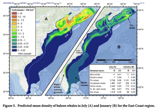
This week, a team from Duke University’s Marine Geospatial Lab released a series of maps and new mapping tools to the public and to other researchers, making available data they’ve been compiling for use in the current round of environmental analysis for the Navy’s east coast and Gulf of Mexico training ranges, and for inclusion in NOAA’s ongoing Cetacean and Sound Mapping project (also known as CetSound).
In addition to an open-access paper published in Nature Scientific Reports, a set of comprehensive species-specific supplemental reports (each one running to over a hundred pages), and a good layman’s overview using the Story Map platform, the Lab also has an online mapping portal, OBIS-SEAMAP, that displays annual animal densities for marine mammals, seabirds, sharks, rays, turtles, and even a few lizards of conservation concern. OBIS-SEAMAP—short for the Ocean Biogeographic Information System: Spatial Ecological Analysis of Megavertebrate Populations—archives hundreds of surveys, satellite telemetry datasets, and photo-ID collections, and has now expanded to include long-term archival of species distribution models. Read the rest of this entry »