Mar 08 2016
An ongoing challenge for ocean regulators has been our relatively coarse understanding of where ocean animals are at any given time. For many species, we’ve been limited to relatively broad-brush data, such as regional population estimates or having a moderately clear idea about particular feeding or breedings areas, with limited knowledge of where these same animals go at other times of year. All this has made the crucial task of estimating the impacts of human activities (Naval sonar and explosives exercises, oil and gas seismic surveys, construction of new shipping ports) somewhere between difficult and impossible—leading to a mountain of EISs, agency determinations, and court filings over the question of how best to protect ocean life from our noisy actions at sea. Confounding matters for all concerned, on the matter of protecting key habitat, the Navy has sometimes prevailed and sometimes lost in recent challenges.
Over the past decade or so, several projects have been bringing data together from a slew of historical studies, along with doing new surveys in the field that flesh out our understanding of animal distributions. These efforts are beginning to bear fruit.
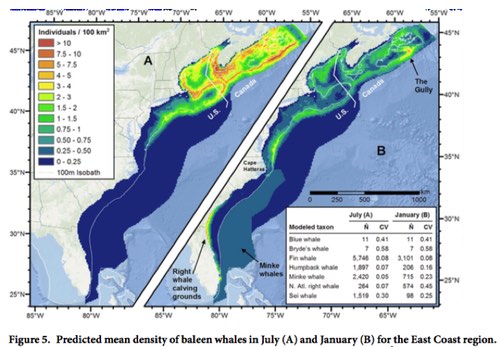
This week, a team from Duke University’s Marine Geospatial Lab released a series of maps and new mapping tools to the public and to other researchers, making available data they’ve been compiling for use in the current round of environmental analysis for the Navy’s east coast and Gulf of Mexico training ranges, and for inclusion in NOAA’s ongoing Cetacean and Sound Mapping project (also known as CetSound).
In addition to an open-access paper published in Nature Scientific Reports, a set of comprehensive species-specific supplemental reports (each one running to over a hundred pages), and a good layman’s overview using the Story Map platform, the Lab also has an online mapping portal, OBIS-SEAMAP, that displays annual animal densities for marine mammals, seabirds, sharks, rays, turtles, and even a few lizards of conservation concern. OBIS-SEAMAP—short for the Ocean Biogeographic Information System: Spatial Ecological Analysis of Megavertebrate Populations—archives hundreds of surveys, satellite telemetry datasets, and photo-ID collections, and has now expanded to include long-term archival of species distribution models. Read the rest of this entry »
Feb 15 2010
The final EIS in the Navy’s multi-year effort to get its training activities into legal compliance with NEPA requirements is heading for the finish line. Adding to the drama, however, is the fact that the Navy is pushing to introduce active sonar training into the Gulf of Alaska—while previous EISs at other training ranges proposed continuing sonar training at or near levels that have been taking place for years, the Alaskan proposal would bring sonar training for the first time into Alaskan waters rich with marine mammal habitat. While the Alaskan range where sonar training would take place is relatively small compared to many of the other ranges on the east and west coasts of the continental US, it is within dozens of miles of key whale habitat, and locals have expressed much concern at public hearings. For more detail, see these links to Alaskan newspaper coverage.


Meanwhile, as the Navy completes the EIS, it has also applied for the Incidental Harassment Authorization from the National Marine Fisheries Service, which announced in early February its intention to issue a Letter of Authorization to permit Navy activities as planned from December 2010 to December 2015. The Navy estimates that its covered activities will take individuals of 20 species of marine mammals (15 cetaceans and 5 pinnipeds) through Level B behavioral harassment. “Further, the Navy requests authorization to take 3 individual beaked whales (of any of the following species: Baird’s beaked whale, Cuvier’s beaked whale, Stejneger’s beaked whale) annually by serious injury or mortality.” See the Navy’s IHA application here, and NMFS notice of intent to issue the LOA here.
Jan 22 2010
NOAA Administrator Jane Lubchenco has announced a series of sweeping new initiatives designed to push the Navy forward in its efforts to understand and mitigate the impacts of mid-frequency active sonar on marine mammals. In response to a request from the Council for Environmental Quality (CEQ), which asked NOAA to conduct a comprehensive review of this controversial issue, Lubchenco outlined several important new initiatives which mark a more active role for NOAA in moving both the science and policy efforts forward. Previously, NOAA had worked closely with the Navy on its Environmental Impact Statements, but had largely rubber-stamped the resultant Navy mitigation plans, which consistently rejected any alternatives that set biologically important portions of US coastal zones off-limits to sonar training.
The new NOAA initiatives include four key elements, three of which dovetail closely with long-time concerns and requests from environmental organizations for NOAA to more actively protect areas of biological significance from both Navy and oil and gas noise, and three of which will help fill key data gaps identified by research scientists over the past decade.
- First, NOAA will work with other civilian agencies (e.g., MMS) to reinitiate comprehensive aerial cetacean and sea turtle surveys, in order to establish more fine-scale population estimates, especially in Navy training ranges. Currently, many Navy EISs rely on coarse, regional population estimates, leading to unrealistic estimations of population density being spread evenly across large areas.
- Second, NOAA’s National Marine Fisheries Service will host a workshop aimed at developing a plan to create a comprehensive “ocean noise budget.” This is a long-time desire of both researchers and environmentalists, and would identify areas in the ocean where human noise is relatively sparse, as well as areas in which new human activity would not add substantially to already high noise levels.
- Third, another NMFS workshop will be organized to identify marine mammal “hot spots” of particular biological significance. All three of these initiatives tie together nicely to bring acoustics into the Obama administration’s stated aim of moving toward more coherent Marine Spatial Planning, a sort of ocean zoning approach that would help guide human activities toward areas where they will have less impact on animals. In a clear indication that NOAA may take a more proactive role in pushing the Navy to leave some areas out of its training zones, the letter stresses that “Protecting important marine mammal habitat is generally recognized to be the most effective mitigation measure currently available.”
- Finally, NOAA has already begun taking an active role in ongoing meetings between the Navy and the National Resources Defense Council; these meetings were part of a legal settlement and are designed to resolve outstanding differences about Navy active sonar operational and mitigation measures. Lubchenco notes that “NOAA’s participation will enhance these discussions and help resolve differing views….I also expect the Navy to be open to new ideas and approaches to mitigation that are supported by the best available science.”
Indeed, including “spatio-temporal restrictions” (areas or times when activity is prohibited) in active sonar permitting has been a major sticking point between the Navy and NRDC and other environmentalists, and is something the Navy has consistently and explicitly rejected in the first round of sonar EISs, which have been finalized over the past year for most of the key Navy ranges (California, Hawaii, East Coast and just this week, the Gulf of Mexico), none of which included any limits on where and when the Navy could do sonar training. “The Navy’s Southern California range is over 120,000 nautical miles in size — about the size of California itself,” NRDC’s Michael Jasny points out. “The Bush administration did not put a square mile of this vast area off limits to sonar.”
All in all, this is a remarkable and very productive first step for this administration as it enters the long-contentious waters of active sonar regulation, ocean noise in general. You can download Lubchenco’s detailed letter at the NOAA website.
